Base Map Preparation Process -1

Preparation of master plan starts with base map preparation before which relevant data of all the necessary information, which is to be presented via base, map is collected. For base map preparation, National Urban Information System (NUIS) Scheme has prepared maps on 1:10,000 scale and made available on NRSC/ISRO Geoportal Bhuvan for Urban Local Bodies for 152 towns. Bhuvan NUIS GIS database comprises 

1)Base layers

Road, Rail, Canal, Transportation nodes, Drainage, Surface water Bodies. 

2)Thematic layers

Urban Land use / Cover, Geomorphology, Lithology, Geological structures, Physiography 

3)Administrative Layers

State, District, Village, City/Town boundaries and Ward Boundaries. Attribute data has spatial layers as, administrative boundaries, forest boundary, settlement and village locations / names and city / town boundaries and non‐spatial data. Other sources of licensed/authentic versions of interpreted satellite imageries can also be used for preparation of base map. 

The Thematic GIS databases available on Bhuvan range from a scale of 1:10,000, to 1:250,000. The important Satellite data and thematic GIS data resources available for utilization for various planning and development are listed below.

Table Bhuvan Satellite data and thematic GIS data resources available

Table Base and Thematic GIS data services

Once the base and thematic layers from the satellite imagery are prepared, other city/town specific information such as, cadastral maps, revenue records, and plans of government agencies and attribute information from Industrial Development Corporations, Public Work Department, Railways, National Highway Authority could be integrated for preparation comprehensive GIS database as required for development plan/ master plan preparation. 

The satellite imageries, Resources at LISS‐4 and Cartosat PAN, can be overlaid on cadastral maps to prepare base map. These satellite images depict field bunds, cart tracks, settlements, tanks and other cultural features like roads, railway network and canals. These features facilitate identification of Ground Control Points (GCP) for tie down satellite image and cadastral map. For overlaying cadastral map with satellite image it is required that cadastral map be generated in vector mode. In this process the main tasks are acquisition of cadastral maps, scanning and digitization of cadastral maps and generation of vector data. Once the cadastral maps in vector mode are available, the geo‐referencing of these maps can be done. The geo‐referencing of digital cadastral maps and overlaying with satellite image consists of the following steps:
  • Acquisition of GCP’s 
  • Transformation model development and assessment 
  • Geo‐referencing of cadastral maps 
  • Validation of Geo‐referenced map, in isolation 
  • Validation of Geo‐referenced map, with neighbourhood 
  • Mosaic generation at Revenue Inspector (RI), Taluk and district level
Good planning and engineering practice dictate the preparation of large-scale maps as a basis for sound community development and redevelopment. In urban areas. and particularly ingrowing urban areas, such large scale maps are currently being compiled at an unprecedented rate by photogrammetric methods. Relatively simple changes in the specifications governing these photogrammetric mapping operations can make the resulting maps not only more effective planning and engineering tools but can, at relatively little additional cost, lay the foundation for the eventual creation of a multipurpose cadastre. 

Design of the base mapping data content and structure must be flexible enough to allow a variety of users to relate the cadastral parcels to specific types of base information. This objective can readily be achieved by creating and maintaining the base mapping data in a coordinated series of different levels or overlays. Photographic and orthophotographic base maps at a minimum contain the complete photographic image of the terrain surface covered to which other levels or overlays may be added to create the complete base map. The primary base map datum is the geodetic reference framework used to establish the location of all other features. The following reference systems are in current use throughout the United States: 
  1. Geographic Coordinates (latitude and longitude) 
  2. Universal Transverse Mercator (UTM) rectangular coordinates 
  3. State Plane Coordinates  
Geographic coordinates provide the principal system used for computation of geodetic control point positions. The UTM rectangular coordinate system is a metric worldwide system of predominate use in federal mapping environments. State plane coordinates are most commonly used at the state and local levels, currently defined in English units but with metric units also widely available. Because of the greater familiarity with their use at the local level, State Plane Coordinates are normally used as the geodetic reference framework in current implementation projects and are recommended for local multipurpose cadastres.


Base Maps

A base map is a map which shows the existing physical pattern of the land upon which survey info analysis or planning proposal can be superimposed. The information required for base map varies from map to map because it largely depends upon its scale, the area covered and the level of planning details. The base map, with its corresponding representation of the topography of the territory, shows the physical reality of the area where the new city plan is to be implemented. This physical reality is expressed through cartography, an absolutely essential component and probably the most important of all those comprising the information necessary for carrying out urban planning. 

A base map is the graphic representation at a specified scale of selected fundamental map information; used as a framework upon which additional data of a specialized nature may be compiled. Within the multipurpose cadastre, the base map provides a primary medium by which the locations of cadastral parcels can be related to the geodetic reference framework; to major natural and man-made features such as bodies of water. roads, buildings, and fences; and to municipal and political boundaries. The base map also provides the means by which all land related information may be related graphically to cadastral parcels. Details to be shown on different level of base map:

For different levels of maps, information in base map is different. 

1) For Regional Level Base Map 

  1. Boundary The boundaries that can be shown at this level are national boundary, state boundaries, district boundaries, Taluk boundaries and village boundaries. 
  2. Road National highway, state highway, major district roads, other district roads and fair weather roads. 
  3. Railway lines Broad gauge and meter gauge lines, bridges are also to be included. 
  4. Topography The major forestland, major hilly areas, rivers and streams, lakes, swamps, marshy lands etc. 
  5. Settlements The urban settlements, rural settlements and important headquarters. 
  6. Contours The contour interval in the base map at the regional level is 100m. 

2) For City Level Base Map 

  1. Planning and administrative boundaries Planning area boundary (if identified), metropolitan boundary, urban area boundary, municipal corporation boundaries and zonal boundaries, census ward, administrative sub-division limits (if any), urban village or rural settlement within the municipal limits or on the fringe of the municipal boundary, cantonment area boundary (if any), grids (artificial or latitudes and longitudes). 
  2. Roads National highways, state highways, major district roads, arterial road, sub arterial road, collector roads, and local roads. 
  3. Topography Hills, water bodies, Rivers and streams, canals, lakes, swamps, marshy lands etc. 
  4. Religious places Religious places such as temples, mosques, churches, and tombs are shown. 
  5. Contours The contour interval shown in the base map at this level generally ranges between 3m to 5m depending upon physiography of town and scale of map. 
  6. Apart from these, all major places of archeological interests, public and semi-public building (important landmark), major agricultural and city forest, district parks, gardens, green belts, floodable areas, Utilities and services lines are also shown in the base map at this level. 

3) The Site Planning Level Base Map 

  1. All accesses to the site
  2. Vegetation such as trees, bushes etc. 
  3. Water bodies 
  4. High tension lines, overhead electric lines, water supply lines including hydrants, sluice valve, sewer lines including man-holes, vent pipes etc. with slope diameter of lines. 
  5. Already existing features like well, brick kilns, quarries etc. 
  6. Contours are drawn at an interval of 500mm. 

Base Map Features 

Before taking up any urban development plan exercise the first task, both from planning point of view and as statutory requirement, is to prepare or obtain reliable, accurate and up‐to‐date base map for the respective town or city for which the plan is being prepared. The amount of information to be represented on the map varies from map to map because information depiction depends on: 

  • Purpose of map 
  • Scale 
  • Projection 
  • Method of map‐making 
  • Draughting skill 

Uniformity of base map with regard to presentation of features, scale, size and notations, facilitates the readability of these maps and comparison of one map with another. Mapping software of Remote Sensing and Geographical Information System are capable of generating maps with uniformity as well as processing data from different platform.  


Design and Implementation of a Public Participation Process

A public participation process is designed and implemented in four discreet stages, as outlined below.

1) Preliminary Design 

  • Situation analysis 
  • Decision process 
  • Information exchange 
  • Public and stake-holders 
  • Planning team 
  • Approvals 

2) Developing the Plan 

  • Establish objectives
  • Identify and address major issues 
  • Identify and involve the stakeholders 
  • Choose techniques 
  • Prepare to provide and receive information 
  • Develop critical path 
  • Budget, staff, resources, logistics, roles and responsibilities 
  • Prepare to give and get feedback

3) Implementation 

  • Follow the critical path 
  • Apply techniques 
  • Provide and receive information 
  • Monitor the process 

4) Feedback 

  • Report to decision makers 
  • Report to participants 
  • Evaluate the overall process

Techniques 

A number of emerging public participation techniques provide the opportunity for shared engagement, which has been difficult to achieve with traditional techniques. Traditional techniques include print publications, public meetings, open houses, advisory committees, workshops, bilateral meetings, and focus groups. Emerging techniques include open space technology, future search conferences, policy dialogue, and a suite of electronic techniques. In general, emerging techniques offer more in-depth opportunities for dialogue and collaboration, with emphasis on value exploration and reaching consensus on shared outcomes in complex situations. It should be noted that public servants and community groups have numerous opportunities to interact with each other, exchange information and gain a better understanding of each other’s views and interests. 

Citizen participation is mainly seen as an instrument to strengthen and support the way representative democracy is functioning now. The local or national government should take and keep the initiative in policy-making. Initiatives ought to be taken from above. The process of involving citizens in politics and policy-making should not lead to the erosion of the primacy of the representative institutions. The central focus of thought is not on citizens, but on the government. The role of participation is mainly an instrumental one. That is, its main objective is to give citizens and their organizations a say in the official political process. Participation is not regarded as a value in itself, but is merely aimed at producing a government. 


Importance of Participation

The planning system is meant to reflect the general wishes of the local community and there is a need on the local authority to consult widely during the formulation of a local plan and in the operation of the development. The fact that the council is made up of elected members ensures a certain level of representation, but wider public consultation is required. When a planning application is submitted the local authority publishes details in the local newspaper and, in some circumstances, a notice is displayed adjacent to the site. In cases of special sensitivity, individual households in an affected area might be asked for their opinions or there may be a small public exhibition. 

However, in most cases, if members of the public wish to find out what is proposed they have to visit the planning department, request the material that has been submitted and examine it on the premises. They can then write to the planning committee if they have any objections. No matter what the scale of proposal, development control can be thought of as a process of negotiation: at its simplest, between the applicant and the local authority, with only rudimentary involvement by the public. 

Characteristics of Participation 

Although any given participation process does not automatically ensure success, it can be claimed that the process will minimize failure. It is a source of wisdom and information about local conditions, needs and attitudes, and therefore improves the effectiveness of decision making. It is a means of defending the interests of groups of people and of individuals, and a tool for studying their needs, which are often ignored and dominated by large organizations, institutions and their bureaucracies. With the goal of achieving agreement about what the future should bring. 

Determination of Goals and Objectives 

The planning that accompanies the design of any participation program should first include a determination of participation goals and objectives. Participation goals will differ from time to time and from issue to issue. Participation is likely to be perceived differently depending on the type of issue, people involved and political setting in which it takes place. If differences in expectations and perception are not identified at the outset, and realistic goals are not made clear, the expectations of those involved in the participation program will likely not be met, and people will become disenchanted. To address participation effectively, the task should conceptualize what the objective is for involving citizens. For example, is the participation intended to; 

  • Generate ideas 
  • Identify attitudes 
  • Disseminate information 
  • Resolve some identified conflict 
  • Measure opinions 
  • Review a proposal 
  • Provide a forum to express general feelings 

Planning for Participation 

Once planners have identified the overall goals and objectives for the participation process, Planning for participation requires the following steps; 

  1. Identify the individuals or groups that should be involved in the participation actively being planned 
  2. Decide where in the process the participants should be involved, from development to implementation to evaluation 
  3. Articulate the participation objectives in relation to all participants who will be involved 
  4. Identify and match alternative participation methods to objectives in terms of the resources available 
  5. Select an appropriate method to be used to achieve specific objectives 
  6. Implement chosen participation activities
  7. Evaluate the implemented methods to see to what extent they achieved the desired goals and objectives 
All Individuals and interest groups should come together in an open forum. In this setting, people can openly express their opinions, make necessary compromises, and arrive at decisions acceptable to all concerned. By involving as many interests as possible, the product is strengthened by the wealth of the input. In turn, learning more about itself strengthens the citizens group. The Process is continuous and ever changing. The product is not the end of the process. It must be managed, re-evaluated, and adapted to changing needs. Those most directly involved with the product; the users, are best to assume those tasks. The professionals role is to facilitate the citizen groups ability to reach decisions through an easily understood process. Most often this will take the form of making people aware of the alternatives. This role also includes helping people develop their resources in ways that will benefit themselves and others. 

A wide range of techniques are available to designers and planners. Some of these techniques have become standard for use in participatory processes, such as interactive group decision making techniques that take place in workshops. At the same time, designers and planners have effectively used field techniques, such as questionnaires, interviewing, focus groups, and group mapping, to acquire information. In general, many of the techniques facilitate citizens awareness of environmental situations and help activate creative thinking. The techniques can be classified as awareness methods, group interaction methods and indirect methods.

Methods of Data Collection 

  • Interviews 
  • Surveys 
  • Reviews and Structured Observation 
  • Case Studies 
  • Small Group Methods (Focus group, Delphi, Charette, etc.) 
  • Secondary data, (e.g., Agency data) 
  • Reviews of Studies 
  • Content Analyses 
  • Diary Methods 
  • Ethnographic Methods (Field Studies, Participant Observation, Tester Audits)


Public Participation in Plan Formulation and Implementation

Public participation has gradually emerged in urban planning since 1960’s. China has introduced public participation concept in urban planning practices for over 20 years. The purpose of public participation is to change the pattern of elite planning, ensure the public benefits and democratic rights, improve the feasibility and practicability of the planning schemes together with the democracy in the planning decision making process. 

The approach of planning should be shifted from top‐down to bottom‐up approach to make planning process more inclusive, comprehensive, and sustainable. Greater public acceptability is desirable, to ensure that plans are relevant. People can participate in the development process in the following realms: 

  • Pre‐plan participation in decision making in vision development, for identification of development priorities.
  • Post‐plan participation before finalization and implementation of development programmes and priorities. 
  • Participation during implementation and evaluation of development programmes and project. 
  • Participation and sharing the benefits of development, managing the assets etc. 
  • e‐Platform and crowd sourcing are coming up as new modes of obtaining feedback speedily. 

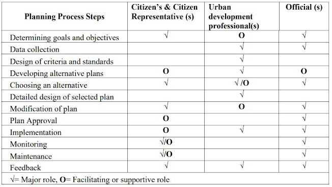
Taking into account the interest, attitude and behaviour of the people, role of urban development professionals and obligations of local authority, a system of participatory plan approach has been suggested. 

The suggested indirect participation of the people is ensured through elected representatives in the Municipal Council / Corporation and Ward committees. The direct participation can be through individuals, citizens, neighbourhood, business, consumer and other such groups. There are several mechanisms and avenues for people’s participation available today, few of these have been presented below. Such mechanisms and avenues can be used to bring wider and more interactive participation of public in planning and developmental process.

Participatory planning approach


1) Community Design Characteristics 

It is a multiple day interactive meetings, workshops and site walks/visits that fosters diverse and community sourced ideas. 

2) Advisory Committees 

Committees made up of representatives guide planning efforts over an extended period of time while regularly meeting during the planning process. 

3) Low cost Demonstrations and Transformations 

Use of blocks and day to day objects to create a low cost model of proposals for visual understanding. Relatively inexpensive temporary transformations are made to test the project and experience changes.

4) Focus Groups 

Allow small groups of stakeholders to provide their knowledge of a project area and discuss their concerns and issues with local authority staff, planning consultants etc. 

5) Other 

Citizens report card, participatory mapping and participatory budgeting etc. 

People can make contributions to the planning process at the implementation stage only if they are presented with a well-articulated and feasible framework of approaches, objectives, alternatives, etc. The participation of the people in local development programme provides the best guarantee that adequate action will be taken in the area itself. Public participation also creates an awareness of the problem and possible solutions among the people and thereby equip them as citizens to exercise choices relevant to development in a rational manner. When such a participation is institutionalized a stable base is created for decentralized exercise of power both on territorial as well as functional bases. 

People's participation has acquired greater significance in a country like ours which is striving hard since independence to bring an overall socio-economic change through democratic  processes. Community development and Panchayati Raj were aimed at securing people's participation in the planning and execution of the programme as a vital aspect of community development. To expand the democratic basis of development policies and administrative actions public cooperation has assumed great significance. Public cooperation is sought in almost each phase of governance and the entire multifaceted development of the people m the various fields, viz., social, economic, educational, cultural and moral. Involvement and sharing of the people in the process of development, particularly m decision making, planning and implementation is in the interest of good government and good administration. 
In a democratic society participation gives the ordinary citizen a means of voicing his opinion and of showing by his behaviour and action that he is able to take on responsibilities. It gives the ordinary citizen a chance to show his willingness to carry out constructive public work and to demonstrate his good citizenship by other means than periodically exercising his right to vote. Participation involves a factor of determination on the part of the person participating. It is in the sense participation means self-motion. People's participation or involvement can be better understood in four senses: 
  • Participation in decision making 
  • Participation m implementation of development programme and projects 
  • Participation m monitoring and evaluation of development programmes and projects 
  • Participation in sharing the benefits of development principles 
Public participation is the involvement of people in the creation and management of their built and natural environments. Its strength is that it cuts across tradition professional boundaries and cultures. The activity of community participation is based on the principle that the built and natural environments work better if citizens are active and involved in its creation and management instead of being treated as passive consumers. The main purposes of participation are; 
  • To involve citizens in planning and design decision making processes and, as a result, make it more likely they will work within established systems when seeking solutions to problems 
  • To provide citizens with a voice in planning and decision making in order to improve plans, decisions, service delivery and overall quality of the environment 
  • To promote a sense of community by bringing together people who share common goals 
Participation should be active and directed, those who become involved should experience a sense of achievement. Traditional planning procedures should be re-examined to ensure that participation achieves more than a simple affirmation of the designers or planners intentions.