Delineation of Region

Delineation of regions involves the grouping together of local units which have similar characteristics according to certain clearly defined criteria and which differ significantly from the units outside the region on the basis of certain chosen criteria. The criteria can be unemployment rates, activity rate, migration trends, per capita income etc. The characteristics should differ significantly from units outside the region. The methods of regional delineation involve

1) Fixed Index Method

Under the fixed index method, a number of characteristics common to regions are chosen (Eg. population, density, per capita income, unemployment, rate of industrialization). An arbitrary weight is given to each index and a single weighted mean is obtained for each region, then contiguous regions with similar indices are grouped together in order to minimize the variance within the group.

2) Variable Index Method

Under the variable index method, variable weights are assigned to highlight the different regions. The weight given to each activity, in each region is different, in accordance with the value or the volume regionally produced. For e.g., if region A is the wheat region and the region B is the coal region, the weight of the wheat index will be the largest in the former, and the weight of the coal index will be the largest in the latter. This method is good when those criteria can be compared with each other. However in those cases where compatibility is not possible (E.g., in case where one feature is literacy and the other is steel production) it becomes necessary to employ the cluster method

3) Cluster Method

Cluster means grouping together. This concept is used in the planning as a strategy to strengthen lateral links and to dissipate growing vertical links in the settlement system. Such a cluster while providing greater viability and threshold for development efforts will also create for themselves a greater bargaining power in bringing about reciprocity in exchange of goods and services. Both at the macro and micro level clustering can be done by superimposing of maps and by developing a composite index of development. This concept is used to implement IRDP (Integrated Rural Development Programme).

Methods for Delineation of Formal Regions

1) Weighted Index Number Method

In this method, some indices (parameters) are chosen and given weights, total weights for each part is separately calculated and areas with similar weights are carved out. This area is termed as ‘region’.

Example: To carve out a region of economic backwardness the parameters chosen were percentage of unemployment and per capita income. Then accordingly the weights were set up. It was decided that for every 1% of unemployment 2 weights shall be assigned and setting 1000 as the base for every 50 points below 1000, 1 weight shall be assigned. Hence more is the total weight more is the backwardness.

Weighted index number method


Suppose we consider a hypothetical area divided into 9 blocks having the given unemployment percentages and per capita income. If we then apply weights to each block as stated in the previous paragraph we will find that we can hatch an area with relatively more economic backwardness.

There are certain demerits of this method. To apply this method, the region must have proper delineated parts. This method can only be applied where quantifiable data is available and this method is not useful for delineating regions having natural/physiographic features.Similarly, you can use this method for employment and income level delineation.

  •     The study area is divided into several localities varying according to unemployment rates and per capita income levels.

  •      The aim is to isolate the main problem region; i.e. the area of economic malaise.

  •      Weights are assigned to each criteria and when taken together and weighted, one of the region can be isolated.

2) The Factor Analysis method

In this method, each parameter is mapped out separately and then all the maps are kept one over the other. The common region that will be carved out after this exercise will form a region.

Used for delineating economic health regions.

  •  Used for delineating economic health regions.

  •  Many of these criteria are interdependent. The factor analysis method can be       used to isolate these factors and to group areas on the basis of factor                   loadings.

  •  ‘Industrial change’ and ‘industrial structure’ are major industrial factors and          ‘population change’ and ‘social structure’ as major socio-economic factors.

  •   These factors help in delineating economic health regions.

Example: To carve out South eastern mineral region. The parameters considered were geology, minerals (coal, iron ore, bauxite and silica), availability of rail, soil, vegetation, climate and population. Each line depicts an aspect and is called girdle.

                        Example for factor analysis method

The area which satisfied 6 girdles was carved out and was called the South East mineral region. Sometimes some parts of the delineated area have administrative conflicts at those moments, adjustment is done on the basis of smallest unit of delineation method.

Methods for Delineation of Functional Regions

1) Flow Analysis Method

Flow analysis builds up functional regions on the basis of the direction and intensity of flows between the dominant centre and surrounding satellites. Each flow will show decreasing intensity as it becomes more distant from the main centre and increasing intensity as it approaches another centre. The boundary of the sphere of influence of the dominant centre will be where the flow intensity at a minimum. When the flow significantly drops that means interaction/origin’s influence drops. In terms of distance, in a particular direction, there is the influence of the node and there onwards it drops. This gives cut off points. 

Features of Flow Analysis Method

  •    Builds up flows on the basis of the direction and intensity flows between the dominant center and surrounding satellites.

  •    Flows may be of several types: economic (road, rail, shopping or commuting); social (such as flow of students or patients); political (flow of govt. expenditure); information (newspapers, telephone calls), etc.

  •   Graph theory: measures the relationship (economic, social, etc) between selected group of centers on the basis of flows between the centers. The no. of telephone calls is the usual flow criteria.

  •     The flows are plotted in matrix form, from which primary and secondary flows into and out of each center can be identified.

Illustrative Example Using Flow Analysis Method

          
 Example using flow analysis method

The no. of telephone calls is taken as the flow criteria. The flows are plotted in matrix form, from which the primary and secondary flows into and out of each centre can be identified. The resulting hierarchy of nodes can plotted as a simple network, providing an insight into the form and extent of functional relationships within an area. Here D is the major centre, with B,E and G subsidiary centres.

2) Gravitational Analysis Method

It is concerned with the theoretical forces of attraction between centres rather than actual flows. The gravity model assumes that the interaction between two centres is directly proportional to the ‘mass’ of the centres and inversely proportional to ‘distance’ between the centres.

·         ‘Mass’ can be population, employment, income, expenditure and retail turnover.

·         Distance can be in physical terms (km), time, price, and intervening opportunities.

·         In mathematical notation

f = k (m1 m2)/d

Where f is the force of attraction between two settlements, m1 and m2 are masses of the two settlements and d is the distance between them. K is a constant.


Types of Regions

A region is an area on Earth's surface marked by a degree of formal, functional, or perceptual homogeneity of some phenomenon. The three main types of regions are formal, functional, and vernacular regions. A formal region, also known as a uniform or homogeneous region, is an area in which everyone shares in common one or more distinctive characteristics. This common characteristic could be a cultural value such as language, an economic activity such as production of a certain crop, or an environmental property such as climate and weather patterns. Whatever the common characteristic is, it sis present throughout the selected region. In certain formal regions, the characteristic may be predominant rather than universal, such as the wheat belt in North America, it is an area in which the predominant crop is wheat, but other crops are grown here as well.

functional region, also known as a nodal region, is a region organized around a node or focal point. The characteristic chosen to define a functional region dominates at a central focus or node and diminishes in importance outward. The region is tied to the central point by transportation, communication systems or by economic or functional associations. An example of a functional region is the circulation area of a newspaper. That area is centered around the city in which the newspaper is published in. The farther away from the city of circulation, the less people that read the newspaper (this phenomenon is known as distance decay). A vernacular region, also known as perceptual region, is a place that people exists as part of their cultural identity. Perceptual regions vary from person to person. They emerge from a person' s informal sense of place. An example of a vernacular region would be the South. My idea of the southern states may be different than my friend's idea of southern states. 

Types of Regions on the Basis of Stages of Economic Development

1) Developed / Development Regions

Developed regions are naturally those which are having a high rate of accretion in goods and services i.e., their share in the GDP of the country is relatively higher. This may be with or without rich natural resources by most certainly because of the use of upgraded technology by highly skilled and motivated persons. A developed region may become ‘overdeveloped’ in certain respects e.g., it may suffer from the diseconomies of congestion. Infrastructure costs become very high and people can go into the jitters due to pollution and stresses of various types. A developed region is the counterpart of the backward region: the ‘positive’ side is emphasized in case of the developed region while ‘negative’ aspects are emphasized in case of the backward region.

A developed region is one, which has exploited its potentialities fully, which has removed the bottlenecks and speed breakers of development. Developed regions emerge of their own because of the comparative advantage or may emerge as a result of the diversion of funds by the government. In many cases imbalances emerge between developed and backward regions and these imbalances can be the creation of planners also. Many times disproportionately high amounts of investment are made in the constituencies of the influential politicians and some regions become far more developed than the neighboring regions.

2) Backward Regions

There can be ‘backward or depressed’ regions in the developing as well as the developed economies. Backward economies are thoroughly depressed regions. There is development even in these regions but these regions have not come out of the low level equilibrium trap. There can be region, which may not be at subsistence level but may be relatively backward. Lack of infrastructure facilities, adverse geo-climate conditions, low investment rate, high rate of growth of population and low levels of urbanization and industrialization are causes and consequences of backwardness.

In less developed countries, even the most ancient occupation (agriculture) is backward and unless it is made progressive with massive real and financial input support, the region cannot come out of backwardness. Some vestigial regions (as the regions inhabited by the red Indians in USA/ or tribal in India) can remain backward and may even remain near the subsistence level. The inhibitions may have ancient traditions and may be smug in their surroundings, but the per capita income may be much lower than in the neighboring regions. A region can be backward because of the high population density or even without it.

3) Neutral Regions/ Intermediate Regions

New towns and satellite belts are designated as ‘neutral’ regions and they promise good prospects of further development because here further employment generation and income propagation is possible without congestion. Such regions can be demarcated around urban centers. Intermediate regions are those regions, which are ‘islands of development around a sea of stagnation’.

Types of Regions Based on the Activity Status Analysis

1) Mineral regions

Many mineral regions promise high growth rates for the region as well as for the prosperity of the country. If mineral- based industries can be developed in the region itself, then industrial development will be less costly because much of the load shedding will be done in the region at low cost. The iron ore deposits of Bailadeela (Bastar District of Madhya Pradesh) are exported abroad, a plant could be established near the ore deposits, it would have brought tremendous development for the region. As the mines continue to yield sufficient minerals and the costs are also not prohibitive, not only the mineral producing region develops but it helps other regions also to develop.

After the minerals exhaust, the region will bear degraded look, people will move away to other areas and the erstwhile area will bear a deserted look. Germany took great pains to rehabilitate such areas and vast pits and trenches were suitably reclaimed for various purposes like water storage, eco-forestry and even cultivation after enriching the soil. If new deposits of minerals cannot be discovered, there can be several ways of reclaiming wasteland and developing non-mineral based activities. Regional planning will require a long-term plan for developing such regions after extraction is no longer a profitable activity. The Middle East countries have made adequate planning to diversify their economies so that after the oil wealth exhausts their economies do not relapse to backwardness.

2) Manufacturing Regions and Congested Regions

Some regions become big manufacturing regions not because they have natural resources but because of the infrastructure development, momentum of an early start, continued government support etc. Autonomous, imitative, supplementary, complementary, induced and speculative investments keep in giving strength to the manufacturing regions. It would be prudent not to develop narrow manufacturing base, otherwise territorial specialization can become a problem if the crop supplying the raw materials fails or if the minerals which are base for the industries, exhaust. In such regions the internal and external economies are available in ever greater measure and such regions keep on developing. When all the thresholds are crossed, such regions become too congested and the diseconomies overwhelm the economies of production – high density, increasing pollution, reduction in the quality of life etc.

3) Cultural Regions

A cultural region can also be quite well demarcated. (French Canada and English Canada are such regions). In India various states are demarcated on the basis of language and culture primarily. There are affinities of cultural origin in such region. A rich cultured region should be rich in economic terms also.

Regions in Regional Economics

1) Homogenous Region

They are formal regions and on the basis of homogeneity in topography, rainfall, climate or other geo-physical characteristic. Economic homogeneity is more relevant for planning. The structure of employment, the occupational pattern, the net migration, the density of population, the resource and industrial structure, if similar in a space, the regions become homogeneous in economic sense. The greater the economic similarities, the greater the interest the economists will have in homogeneous regions. Internal differences in a region are unimportant. Sometimes, a clear cut homogeneous region may have, many differences in sub-regions as to make them quite different yet a region may remain ‘homogeneous’.

Scotland or Uttar Pradesh are clear cut homogeneous regions but in topography the hilly districts of Uttar Pradesh have nothing in common with the districts of the plains. Eastern and Western districts are also different but Uttar Pradesh remains a homogeneous region in administrative terms. Thus a homogeneous economic region can have differing physical characteristics. Homogeneous region on economic or political criterion may have a lot of heterogeneity from several other stand points.

Ø Formal Regions

Regions defined formally, often by government or other structures, are called formal regions. Cities, towns, states, and countries are all formal regions, as are things like mountain ranges. Formal regions often nest inside one another, so that when you are standing in the middle of Trivandrum, you are in the city of Trivandrum, which is part of state of Kerala, which rests inside the southern region of India, which is in the country of India, which is on the continent of Asia. All of those are formal regions.

A formal region is homogeneous with reference to some geo-physical characteristic such as topography, climate of vegetation. This is physical formal region. Later on there was a shift from this narrow approach to a broader approach and economic, social and political criteria were also applied. An industrial or agricultural or plantation region is a formal economic region; or a state governed by a particular party is a formal political region.

Ø Functional regions

It consist of a central place and the surrounding areas that are dependent upon that place, such as a metropolitan area. The functional region is concerned with interdependence. This is a geographical area in which there is economic interdependence. The nodal regions are functional regions between which there are flows of men, material and money.

Ø Vernacular regions

A vernacular region is an area that has been identified based on people's perception of culture.

2) Polarized / Nodal / Heterogeneous / Functional Regions

Polarized or nodal regions look to a centre-a large town usually-for service. Its influence extends beyond the area of the city. The villages are dependent upon it for services and marketing. There is little concern for uniformity when a polarized or nodal region is taken. The city region need not correspond to the administrative region because hinterland of several clear cut regions may be served by a city. (For example even the persons of Gwalior may visit Delhi for buying some consumer durables of high value. A capital city may attract customers form several districts around the capital city.)

A nodal region will have heterogeneous economy around it. Regional economists are more concerned with what happens within a nodal region and spatial dimension of the nodal region assumes importance. Population and industries agglomerate and there are core regions with higher per capita income generation through higher production of goods and services. Within regions there are dominant cities or nodes to which flows of inputs, goods, people and traffic gravitate. Within the cities there are nuclei that form business and social centres and which are discernible at a glance from an intra-metropolitan traffic-flow density map.

As the distance increases, the costs of overcoming frictions will rise and the people of different areas will look for a different nodal point. Each region will have one or more dominant nodes and it will be interesting to find and record as to which interior areas form the areas of influence of one or the other node. Nodal regions provide an understanding of the functional relationship between settlements, which fill up the space. These heterogeneous units in rural and urban areas are functionally related because each settlement cannot have all the functions and facilities. All functions require a particular threshold population and other facilities (Each settlement cannot have a college or unless there is electricity, there cannot be cinema hall or a bank branch).

3) Planning Regions

Planning regions depend upon the type of multi-level planning in the country. A very small country will naturally have one level planning. A planning region in a multi-level setup requires regional plan, which is a spatial plan for the systematic location of functions and facilities in relation to human settlements so that people may use them to their maximum advantages. In fact more important than reducing the regional disparities is the task of ensuring that backward region and rural areas have basic minimum needs. Planning region for different activities can be different and a regional plan will be locational in character for that activity/function.

For comprehensive planning, there has to be a national plan and then a state plan and finally district/block plans. Since a planning region is a sub national area demarcated for the purpose of translating national objectives into regional programs and policies, and since plan formulation and implementation need administrative machinery, administrative regions are generally accepted as planning regions.

The hierarchy of planning region would be (i) national level (ii) macro level (iii) state level (iv) meso level (v) and micro level. A planning region must be large enough to take investment decisions of an economic size, must be able to apply its own industry with the necessary labor, should have a homogeneous economic structure, contain at least one growth point and have a common approach to and awareness of its problems. In short, a planning region should be defined according to the purpose of one’s analysis. Ideally a planning region should have adequate resources to establish a satisfactory pattern of savings, capital formation, investment, production, employment, income generation and consumption pattern. It means that the area should be economically viable.

Types of Regions in Multi-Level Planning Perspective

1) Macro Region

Macro region is naturally bigger. Macro region can be a state of even a group of states, if the states of a country are not big enough. For example, in India there are East, West, North, South and Central Zones and ‘Zonal Councils’ of which function is mutual consultation, developing cooperation and mutual counseling. In a sense macro regions are second in hierarchy, next to the national level. It is also possible that a physical macro region may comprise parts of different states of a country for project planning purposes (e.g. big river valley projects, an electric grid of different states and for the purpose of a particular activity planning).

State boundaries are not respected in the sense that the macro region may transcend or cut across administrative boundaries of the states of a country. A macro region may not be uniform or homogeneous in all respects. It may have homogeneity in one respect (physical complementarity) and may have heterogeneity in other respect (administrative boundaries). A macro region should have a common resource base and specialization in that resource base, so that production activities can develop on the principle of comparative advantage based on territorial division of labor (India has been divided into 11 to 20 macro regions, agro-climate or resource regions). The planning Commission of India would have just 5 zonal councils-Eastern, Northern, Central, Western and Southern comprising of certain states but beyond this there is no macro-regionalization in India. These so-called macro regions of India have to have interstate cooperation in the matter of utilization of river water and electricity grids etc.

2) Meso Region

Meso region can be identified with a ‘division’ of a state. Chattisgarh region, Bundelkhand region, Baghelkahand region, Mahakoshal region is usually a sub-division of a state, comprising of several districts. There should be some identifiable affinity in the area which may even facilitate planning. It can be cultural or administrative region and it will be even better if it is a homogeneous physical region (resource) region. A meso region can also become a nodal region provided the combined micro regions or parts thereof can be developed in a complementary manner.

3) Micro Region

In multi-level planning, district is the micro region. It becomes the lowest territorial unit of planning in the hierarchy of planning regions. The most important reason why district is the most viable micro region for planning is the existence of database and compact administration. This is the area, which is viable for plan formulation with administration for plan implementation and monitoring. A metropolitan area can be one micro region and the area of influence can be another micro region. A nodal point is also a micro region, though in many cases micro regions are basically rural areas, which may have a number of minor nodes without any organizational hierarchy influencing the entire area. The basic characteristic of a micro region is its smallness.

4) Micro – Minor Region

This is the region which is associated with, what is called, the grass-root planning. A micro-minor region can be a block for which also data exists now and for which there may be a plan. The block level plan is integrated with the national plan, through the district and state level plans. A block level plan is not surgically cut portion of the district plan, which has its own logic and linkage. At block level, most of the officers will be more concerned with the implementation of the plans than formulating the plans. At block level, the main exercise will be to take into account of the physical and human resources and to find out the prime moving activities which will enable the block people to make best use of the development potential of the block to meet the basic needs of the people.

Minimum needs can be satisfied with the production of basic goods with the help of low entropy local resources. In fact, planning of the development of the transport, communication, banking, education, medical and many service facilities has got to be done at the national level. At the panchayat level, basic goods and services can be arranged through the efforts of the local people. Many activities can be so planned that they improve the socio-economic conditions of the people without being the part of the national plan.

Several activities can be undertaken with the cooperation of the local people, with minimum of financial and real resource support from outside e.g., development of dairying, animal husbandry, pisciculture, poultry, soil conservation measures, optimization of the cropping pattern, production of inputs locally, improving the storage and transport facilities can be done at the micro minor level. Many agro based industries and tiny sector guild-type activities can be developed at the micro-minor level. A good planning can secure ‘ruralization of the industries’ instead of ‘industrialization of rural area’. This will involve production of goods ‘by the masses for the masses and near the masses’.


Planning Regions

A planning region is a segment of territory  over which economic decisions apply. The term planning here means taking decisions to implement them in order to attain economic development. Planning regions may be administrative or political regions such as state, district or the block because such regions are better in management and collecting statistical data. Hence, the entire country is a planning region for national plans, state is the planning region for state plans and districts or blocks are the planning regions for micro regional plans. 

For proper implementation and realization of plan objectives, a planning region should have fairly homogeneous economic, to zoographical and socio-cultural structure. It should be large enough to contain a range of resources provide it economic viability. It should also internally cohesive and geographically a contagion area unit. Its resource endowment should be that a satisfactory level of product combination consumption and exchange is feasible. It should have some nodal points to regulate the flows. Seven major regions in India are:
(1) South India
(2) Western India
(3) Eastern Central India
(4) North-Eastern India
(5) Middle Ganga Plain
(6) North-Western India
(7) Northern India

Town and Country Planning Organization Regions
In 1968, the Town and Country Planning Organization suggested a scheme of planning regions delineated on the principle of economic viability, self-sufficiency and ecological balance at the macro and meson levels. The emphasis of the scheme was to introduce regional factor in economic development. This approach would complement the macro planning at the national level, with a component of regional policies, aimed at reducing regional disparities in the development. The macro- regionalization sought to link a set of areas, rich in one type of resources with areas having complementary resources or even resource poor areas, so that the benefits of economic activity in the former may flow into the latter. These planning regions cut across the State boundaries, but do not completely ignore the basic administrative units. The 13 macro regions proposed under the scheme include:
(1) South Peninsular (Kerala and Tamil Nadu)
(2) Central Peninsular (Karnataka, Goa, Andhra Pradesh)
(3) Western Peninsular (Western Maharashtra coastal and interior districts)
(4) Central Deccan (Eastern Maharashtra, central and southern Madhya Pradesh)
(5) Eastern Peninsular (Orissa, Jharkhand north-eastern Andhra Pradesh)
(6) Gujarat (Gujarat)
(7) Western Rajasthan
(8) Aravalli Region (Eastern Rajasthan and wasted Madhya Pradesh)
(9) Jammu, Kashmir and Ladakh
(10) Trans Indo-Genetic Plains and Hills (Pune Haryana, Himachal Pradesh, West Uttar
         Pradesh and Uttaranchal)
(11) Ganga-Yamuna Plains (Central and eastern Uttar Pradesh, and northern Madhya Pradesh)
(12) Lower Ganga Plains (Bihar and West Bengal Plains)
(13) North-Eastern Region (Assam and north-eastern states including Sikkim and north 
       Bengal)

Components of Regional planning 
Economy
Housing
Environment


Regional Planning

Region means a tract of land; any area; a portion of earth’s surface. Regional planning deals with the efficient placement of land use activities, infrastructure and settlement growth across a larger area of land than an individual city or town. Regional planning is a sub-field of urban planning as it relates land use practices on a broader scale. Regional planning deals with the planning of areas which constitutes both urban and rural areas. Urban planning, city planning or town planning concerns a city or a delimited urban area which covers a city or town, however a regional plan can have number of urban areas.

A ‘region’ in planning terms can be administrative or at least partially functional and is likely to include a network of settlements and character area. A region scheme usually covers more than one local government area. The content of the scheme may vary for each region, but they generally set out broad land use zones or policy areas and identify land required for regional purposes. Regions require various land uses; protection of farm land, cities, industrial space, transportation hubs and infrastructure, military bases and wilderness. 

Integrating a much wider areas for overall growth of region is the purpose served by regional planning, planning for integration of rural area and the overall balanced development of the region. Fulfilling the needs of a backward region and providing higher order services for relatively developed areas. Strategies are formulated carefully to keep the goods and resources available to all the places as per their requirements.

Regional planning encompasses even larger area when compared to city planning, number of cities might be covered when considering a region but rural area remains at the core for which planning is to be done. Along with rural areas many lower level towns in addition to the villages witnessing transformation to towns also adds up to area for which regional plans is made. Regional plans can cut across the boundaries of different states.

Regional planning also helps in reducing the conflicts and competition for resources between cities in a region. Developing small towns or satellite towns helps in relieving the stress from higher order town thus increasing efficiency. Regional plans takes into account the economic, spatial and environmental goals and tries to address national level issues. Integrated development and critical analysis of functional linkages is one of the key to achieve the desired growth.

Unlike city planning where land use plans are prepared regional planning lays emphasis on policy for the region. Policies are them elaborated and objectives are formed which differ from area to area within the region. Regional plans are a must when cities start to influence development even in far places which might end up in under-utilization and wastage of resources without proper planning.
Polices have a larger and longer impact on the overall growth of region and might conflict with the land use plan or plan prepared for a specific city. Allocation of funds for different activities and different areas can also be taken up by the regional planning board/authority. Government intervention such as implementing a new scheme or policy for a region can also boost the growth perspectives and aide the policy prepared by regional board.

Reduced disparities help directly and indirectly by reducing forced migration, reducing trip lengths, providing better and more job opportunities in nearby areas, having the required services instead of letting them emerging randomly. A Special Economic Zone (SEZ) are also established to support the growth of a region and attract investments.

Regional plans take into account the existing condition of an area and all the surrounding areas. The urban area or the core area might have its own development plan in place for its growth and in such cases the existing plan is also taken into account. The existing plan helps in understanding the vision and growth of the existing urban areas and helps in formulating better policies for the surrounding area. Regional plan might help the existing urban area by decongesting it by catering to the need of satellite cities or developing nearby regions for industrial units.

City Planning & Regional Planning
City planning focuses on the land use plans, spatial growth and policies which are at local level (affecting that particular city or town), whereas in case of regional planning the emphasis on the policies is more. Those policies becomes the guidelines for the urban areas and their existing plans are modified accordingly. This helps in meeting the larger requirement of the whole region.

Additionally, regional plans cover more of national level policies and issues and strengthens integrated development. City planning looks as a limited area when compared to a regional plan. Regional plan covers rural areas and undeveloped areas too which are usually not covered in town plans. The categories, chapters, topics and aspects covered in both plans also differs because of the different needs and the existing developments. Village area, forests, undeveloped land and waste land might be completely missing from a city plans whereas it forms an important part of regional plan.

Importance & Need of Regional Plan
A city or any area might grow in size and hamper the development on its surrounding area. Over the decades it starts competing with the surrounding areas and this results in imbalance. It creates economic as well as functional misbalance in areas. Increases migration, decreases efficiency, results in undue waste of resources and might also find it difficult to meet its needs. To prevent such imbalance regional plans are very much required.

It helps in reducing disparities, promoting growth, promoting sustainable development, economic growth of collective region based on its potential. Also, issue of migration is also solved to an great extent because the required facilities are more evenly distributed rather than being concentrated in a specific urban area. These plans ensures a much better connectivity within the region and takes care of future growth.

Implementation of Regional Plans
Since regional plans covers various types of settlements they require multiple agencies working together for its implementation. This can be done in various manner, either forming a new development authority/regional board or giving this responsibility to an existing development authority. This newly formed body or the new department in existing development authority then works actively with various other departments. This is required because regional planners need to have a broad overview of the whole region. The plan formed needs to meet the requirement of whole region and at same time should also cater to the existing requirements.
Allocation of funds is another important aspect of regional planning as the funds are collected and received from various sources. There are various sources since the area covered under a regional plan is a part of various states and different administrative areas. Thus funding might be collectively from state government, central government, special allocation of funds and partially by its own means.

Objectives of Regional Planning
  • Economic growth
  • Attaining economic equality and social justice
  • Achieving full employment
  • Attaining economic self-reliance
  • Modernization of various sectors
  • Redressing imbalances in the economy
Principles of Regional Planning 
  • Resist development in flood plains or along earthquake faults. These areas may be utilized as parks or unimproved farmland.
  • Designate transportation corridors using hubs and spokes and considering major new infrastructure.
  • Some thought into the various settlements in the region may play, for example some may be administrative with others based upon manufacturing or transport.
  • Consider designating essential nuisance land uses locations, including waste disposal.
  • Designate green belt land or similar to resist settlement amalgamation and protect the environment.
  • Set regional level policy and zoning which encourages a mix of housing values and communities.
  • Consider building codes, zoning laws and policies that encourage the best use of the land.


City Region

City regions are the products of relationship among various orders of cities and their surrounding areas. A city has its ‘dependents’ which are linked with it by virtue of their dwellers’ requirements fulfilled by the city’s various service-institutions. Dependent centres of a city are generally smaller in size and they do not possess those specialized services which are only available at the neighbouring city of higher order than the dependent centres.

Structure of City Region 
The city region is an area around the city over which the city exercises a dominant influence in relation to other neighbouring cities of equal importance. This simplified definition of the city region raises a number of conceptual problems which need further elaboration. Thus, the structure of a city region consists of a series of areas of influence and areas of dominance, apart from sets of smaller city regions which nest within it. It is pertinent at this stage to examine three basic notions in relation to the structure of the city region: (i) the concept of area of city influence, (ii) the concept of area of city dominance, and (iii) the concept of the city region.

i) Area of City Influence
No city is independent. An independent city cannot exist. A city may be administrative, industrial, agricultural, and cultural or of any type; it must have its connections with the outside world. Similarly, areas outside a city are also not independent. They too somehow have to give and take and are not independent. The fact is that there exists mutual relationship between a settlement and area surrounding it. Sometimes, the relationship is concomitantly not restricted locally or regionally but it has its far and wide spheres of influence.
The areas of city influence are contiguous areas around a city from where people commute to the city to obtain certain goods or services. A cinema hall in a city may attract patrons from several villages around the city. The continuous area encompassing all these villages is the area of influence of the city with respect to entertainment through the cinema. Likewise, various institutions in the city such hospitals, colleges, schools and so on have their corresponding areas of influence. The areas of influence for different services and goods may cover smaller or larger areas around the city and their shapes may also differ. Thus it is possible to visualize a large number of service areas around a city.

ii) Area of City Dominance 
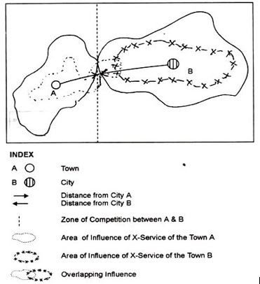
In any landscape one would expect to find a number of cities of the same or similar importance, and the areas in between these cities are often served by more than one city. In other words, the areas of influence of neighbouring cities tend to overlap; thus generating a zone of competition in between .In the middle of the zone of competition one can define a boundary which separates the areas of dominance of the competing cities. Within this boundary, the city exercises a dominant influence - its influence there is greater than the influence of any other city. The area of dominance of a city is an exclusive area and is, therefore, of great significance in terms of territorial or regional divisions. Further, the dominant area in reality is dominant not only with respect to one or two services, but with respect to all services of equal importance. Thus, the area of dominance is a multifunctional area, while the area of influence is essentially a uni-functional area.
A city tends to exert a dominant influence over a small area in its immediate neighbourhood by virtue of the provision of specialized services. It must be borne in mind that there are several areas of dominance because a city possesses more than one service to provide around it. In case of India, majority of cities have no clear specialization in any one economic activity, but in reality they have diversification of several economic functions and services. This has resulted into several areas of dominance around a city. Each of the areas of dominance has its own hierarchical level. The largest of these areas of dominance forms the limit of influence of the city known as ‘city region’; while the smaller ones are known as areas of dominance
Each city generally forms the core of a larger area, and dominates the area by virtue of several service areas within it. The dominant area is actually the city’s spheres of influence. The area of dominance of ‘spheres of influence’ consists a number of single feature nodal regions within it. City’s area of dominance tends to wane gradually with the distance outwards from the city core. Finally, the dominance disappears at a point where the influence of some competing urban centre reaches.

Area of city influence and competition

iii) City Region 
The areas of city influence and dominance are further complicated by the existence of a hierarchy of cities and urban places which give rise to sets of areas of influence and dominance, one within the other. The city region may be defined as the area of dominance of a city corresponding to its hierarchical level. However, the same city also performs functions of a lower hierarchical order. As a result, each city may have more than one area of dominance.
In fact, several areas of dominance fall within the city region in a concentric form. Similarly, for each hierarchical level we have a set of areas of influence representing each service or function. City-regions are becoming increasingly central to modern life and all the more so because globalization has reactivated their significance as bases of all forms of productive activity, no matter whether in manufacturing or services, in high-technology or low technology sectors. 

City Regions in India
Major city regions 
  • Maharashtra – Gujarat sector
  • Delhi nucleus
  • Kolkata - Howrah node
  • Chennai - Bangalore sector
Minor level city regions 
  • Hyderabad - Vishakhapatnam
  • Kanpur - Lucknow
  • Jaipur
  • Nagpur
  • Patna
  • Kochi - Madurai sector
  • Coimbatore
  • Vijayawada
  • Ambala – Amritsar - Jullunder
  • Chandigarh
  • Agra


Rural-urban Fringe (RUF)

The rural–urban fringe, also known as the outskirts, rurban, peri-urban or the urban hinterland, can be described as the "landscape interface between town and country" This is found at the edge of a town or city and is where town meets country.
Rural-Urban fringe is an important concept in settlement geography. The rural-urban fringe is the boundary zone outside the urban area proper where rural and urban land uses intermix. It is the area where the city meets the countryside. It is an area of transition from agricultural and other rural land uses to urban use. Located well within the urban sphere of influence, the fringe is characterized by a wide variety of land use including dormitory settlements housing middle-income commuters who work in the central urban area. Over time the characteristics of the fringe change from largely rural to largely urban. Suburbanisation takes place at the municipal boundary of rural-urban fringe.
Increasing demand for land in the rural-urban fringe area because:
  • Land is cheaper – as the accessibility of the rural–urban fringe is lower than that of the inner city areas and most of the people have to travel to the inner city for work, fewer people are willing to live in the RUF. Thus the land prices are lower.
  • There is less traffic congestion and pollution – as the area is a new development in the outskirts, and the population living in the area is lesser than the inner city, the traffic congestion and pollution levels are lesser.
  • There is easier access and a better road infrastructure – as it is a newer development with a lot of space available.
  • There is a more pleasant environment with more open space – the amount of open space decreases with time as the extent of development increases, and so does the friendly environment.
Beneficial development in the rural-urban fringe area:
The rural-urban fringe is characterized by a mixture of land uses, most of which require large areas of land.
  • Housing developments as urban sprawl continue
  • Science and business parks
  • Hypermarkets and superstores
  • Retail parks and out of town shopping centers
  • Office developments
  • Hotels and conference centers
  • Airport expansion
Problems caused by developing the rural-urban fringe:
  • Large areas of the countryside may be lost
  • Buildings may be out of character with existing rural buildings. Thus the loss of aesthetic sense
  • Villages may become suburbanized
  • Traffic is likely to increase (both cars and lorries)
  • There may be an increase in pollution (noise and air)

Uses of Rural urban Fringe and its Impacts

Uses

Positive Aspects

Negative Aspects

Agriculture

Many well-managed farms and small holdings

Farms often suffer litter, trespass, and vandalism; some land is derelict in the hope of planning permission

Development

Some well-cited, carefully landscaped developments such as business and science parks

Some developments, such as out of town shopping areas cause heavy traffic flow and pollution. Unregulated businesses such as scrap metal and caravan storage. Airport expansion

Urban Services

Some areas such as reservoirs or cemeteries, may be attractive.

Mineral workings, sewage works, landfill sites, etc. can be unattractive and polluting

Transport

New cycle ways and footpaths can improve access to countryside

Motorways destroy countryside and promote new development, particularly near junctions.

Recreation and sport

Country parks, sports fields and golf courses can lead to conservation.

Some activities such as stock car racing and scrambling to erode ecosystems and create localized litter and pollution

Landscape and nature conservation

Many SSSI (Sites of Special Scientific Interest) and AONB (Areas of Natural Beauty)

Much degraded land, Eg. land ruined by fly-tipping; many SSSIs under threat